Shanghai Daiyu Education Equipment Manufacturing Co., Ltd.
Language:


With the application of high-tech in China and the penetration of electronic information technology, as well as the requirements of modern precision agriculture and the rapid development of high-tech agricultural machinery . Agricultural machinery GPS satellite positioning and automatic navigation driving have become an important part of modern agriculture. It plays an important role in many agricultural machinery operations such as sowing, fertilizing, spraying, harvesting, land preparation, and ridging, and has broad development prospects.
1 System composition and working principle
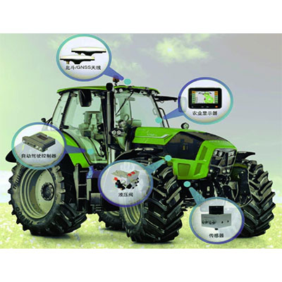
1.1 System components: M*nly include navigation light target, direction sensor , communication module, navigation controller, hydraulic controller, etc.
Navigation light rake: Receives the positioning signal of the GPS, and after setting the navigation line, performs automatic str*ght-line navigation according to the operating width of the unit. The technical feature is that it can generate navigation lines during operations when there is no operation navigation map. Under the positioning of GPS, it can accurately guide the str*ght-line walking operation of agricultural machinery in the field, so that the unit's operation is not heavy or leaky, and it has operation area calculation statistics. and other functions.
Direction sensor: Sends accurate corner information to the navigation controller.
Communication module: receives differential data from the base station.
Navigation controller: The core of the automatic driving system sends instructions to the hydraulic system by receiving positioning information from the GPS and angle information from the direction sensor.
Hydraulic controller: The hydraulic controller changes the flow and direction of the fuel tank according to the instructions sent by the navigation controller to ensure that the agricultural machinery travels according to the set route.
1.2 Working principle
Set the vehicle walking line on the navigation light target and set the navigation mode, str*ght line or curve. By receiving base station differential data, centimeter-level satellite positioning is achieved and positioning information is transmitted to the controller in real time. The direction sensor sends the wheel's movement direction to the controller in real time. The navigation controller sends instructions to the hydraulic control valve in real time based on the coordinates of the satellite positioning and the rotation of the wheels. By controlling the flow and direction of the oil in the hydraulic system, it controls the driving of the vehicle and ensures that the vehicle follows the route set by the navigation light rake.
2 Actual work situation
2.1 Improve land utilization.
The base station of this system is located in the farm's agricultural machinery management service center. The equipment is required to work 24 hours a day. The coverage radius of the base station can reach 50KM, which can cover the entire working area of the site and meet the requirements of farm agricultural machinery field operations. When agricultural machinery uses the automatic driving system to perform operations such as ridging, sowing, spraying, and soil preparation, the deviation between the combined lines and the linearity deviation per kilometer can be controlled to 2.5 centimeters, reducing crop production input costs and improving the quality of agronomic operations. Avoid "re-leakage" during the operation process. Reduce production costs, improve land utilization and increase economic benefits.
2.2 Improve locomotive time utilization and work quality
This system improves the operating performance of the locomotive, extends the operating time, can realize night sowing operations, and greatly improves the locomotive's attendance rate and time utilization. At the same time, this system can reduce the labor intensity of driving operators. During the operation, the driving operators do not need to drive the steering wheel and can spend more time observing the working conditions of agricultural tools, which is beneficial to improving the quality of field operations.
2.3 Strong terr*n adaptability
The system can be used on flat or sloping land. The controller's terr*n compensation technology continuously corrects and compensates for the pitch and roll attitude of agricultural machinery to achieve the purpose of accurate navigation and driving.
Take ridging operations as an example: Traditional ridging operations rely on the driver's own experience, and it is difficult to guarantee the accuracy of str*ghtness and joint lines, especially when the area and slope of the plot are large. The situation is unavoidable. Double leakage and excessive deviation of the joint line during operation directly lead to an increase in production costs and a decrease in land utilization efficiency. Using this system can avoid the above phenomena from happening. At the same time, the system also has functions such as real-time recording of operating status and calculation and statistics of operating area. These have advantages over traditional agricultural machinery operations.
2.4 Properly deploy locomotives
Through GPS satellite positioning, the field operation status of the locomotive can be grasped in real time, including the locomotive's operating location number, operating speed and other information. The real-time operation status will be displayed on the large screen of the information center, allowing agricultural machinery managers to monitor the locomotive's field operation status at any time. , carry out unified command and dispatch of all locomotive operations in a scientific and reasonable manner.
3 Things to note
3.1 The AB line must be set at a distance from the forest belt according to farm requirements. The specific distance should be kept as parallel to the forest belt as possible according to the actual situation of the land number, so as to fully utilize the land, avoid waste and meet standard operations.
3.2 When multiple vehicles use the autonomous driving system to perform the same operation at the same location, the AB lines between the vehicles must be parallel to ensure that the quality of the operation is not leaking or heavy.
3.3 When using automatic driving, when you need to accelerate, it is best to reduce the oil appropriately first, and then slowly increase the accelerator to the required position after upshifting. This can ensure the str*ghtness of the operation. When you need to decelerate, it is best to first Refuel and then downshift. Only by operating the locomotive correctly can the str*ghtness of the operation not be affected.
3.4 When using autonomous driving to carry out suspended agricultural equipment operations, it is best to move forward slowly. After getting online, slowly fall to the edge of the field and confirm that it has entered the trench before putting down the agricultural equipment for operation. When using automatic driving for towing operations, it is best to use automatic driving after manual driving is online. This can save vehicles and agricultural tools, ensure safe operation, and avoid accidents.
3.5 When using automatic driving operations, you must not sleep or lose concentration to avoid safety accidents.
3.7 Technical indicators
|
project |
unit |
design value |
|
model |
/ |
Beidou high-precision agricultural machinery automatic driving system |
|
Steering control type |
/ |
Hydraulic solenoid valve control |
|
Vehicle computer processor model |
/ |
i.MX6 |
|
Vehicle computer memory |
GB |
1 |
|
Car computer hard drive |
GB |
8 |
|
Vehicle-mounted computer operating system and software version |
/ |
Android 4.5 |
|
On-board computer display resolution |
/ |
800×480 (7 inches) |
|
On-board computer interface information |
/ |
30pin car interface |
|
Vehicle-mounted computer data input and output protocol |
/ |
Universal serial port protocol; CAN bus protocol; 100M Ethernet |
|
Satellite receiver type and frequency |
/ |
Multi-satellite and multi-frequency GPS: L1 C/A, L2E, L2C, L5GLONASS: L1 C/A, L1 P, L2C/A, L2 P, SBAS: L1 C/A, L5, Galileo: L1 BOC, E5A, E5B, E5AltBOC2,QZSS: L1 C/A, L1 SAIF, L2C, L5, BDS: B1, B2/B1, B3 |
|
Satellite receiver motherboard firmware version |
/ |
1.4-10707 |
|
Number of satellite receiver channels |
/ |
220 |
|
Satellite receiver interface types |
/ |
48pin car interface |
|
Satellite receiver differential type |
/ |
CMR, RTCM2.0, RTCM 3.0, RTCM 3.2, etc. |
|
Satellite receiver data update rate |
Hz |
≤50 |
|
Satellite receiver receiving antenna type |
/ |
Integrated antenna |
|
Steering control system angle sensor model specifications |
/ |
WAS-3106 |
|
Hydraulic valve model specifications |
/ |
HT800946 |
|
Switch to controller motherboard firmware version |
/ |
V1.6.0 |
|
Mobile station signal coverage |
km |
≥5 |
|
Fixed base station signal coverage |
km |
≥15 |
|
Base station radio transmitting equipment frequency |
MHz |
223~235 |
|
Mobile base station radio transmitting equipment power |
W |
5 |
|
Fixed base station radio transmitting equipment power |
W |
25 |
|
Integrated parts |
/ |
Satellite antenna, satellite receiver, controller integration |
3.8 System components
satellite navigation terminal
· Simple user operation and viewing interface
· IP65 protection grade industrial terminal, waterproof, dustproof and vibration-proof
· 8-inch high-brightness display, clearly visible under sunlight
· Wide temperature range of -40~70℃, suitable for operations in special areas and extreme environments
· Provides displays for navigation, driving and precision agriculture functions
· By connecting high-precision satellite input devices
Driving controller
· The automatic vehicle steering system is the core equipment in the entire autonomous driving system
· Built-in 3D gyroscope and accelerometer, combined with inertial navigation technology, to improve navigation accuracy
· PID control, closed-loop control, hydraulic control and steering control and other algorithms
· Waterproof, dustproof and shockproof design, sturdy and durable
· Sense the body posture and enter automatic correction mode
·Support multiple operating modes such as AB str*ght line, curve and circular curve
Beidou/GNSS receiver
· High-precision Beidou/GNSS positioning and directional receiver
· Support Beidou/GPS/GLONASS/Galileo/SBAS
· Supports configuration as fixed and portable differential base stations
· High receiving sensitivity improves vehicle positioning and navigation accuracy
· Real-time output of high-precision RTK differential data
· Key equipment to improve the accuracy of autonomous driving operations
Beidou/GNSS antenna
· The satellite receiving antenna adopts a high-g*n inert multi-frequency antenna
· Supports China’s Beidou/GPS/GLONASS/Galileo satellites
· High receiving sensitivity and strong signal receiving ability
· Sturdy design structure, waterproof, dustproof, shockproof, high and low temperature resistant
hydraulic valve
· Hydraulic control system converts, transmits and controls energy
· Ensure that the tractor always follows the set route
· Made of alloy material, flexible control, small impact and vibration, and low noise during operation
· Real-time control of hydraulic flow and flow direction according to instructions sent by the control unit
Angle sensor
· Detect the left and right steering angle of the vehicle’s front wheels and provide feedback to the controller
· Used to correct and improve the str*ght-line driving accuracy of vehicles
· Use aluminum alloy material to ensure the rigid connection between the vehicle's front axle and the angle sensor
· Ensure that the detected angle data matches the actual wheel steering angle
 Wechat scan code follow us

24-hour hotline+86 18916464525

Phone18916464525
ADD:Factory 414, District A, No. 6, Chongnan Road, Songjiang Science and Technology Park, Shanghai ICP: Sitemap